
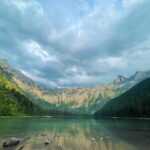
Introduction of Lehigh Gorge State Park
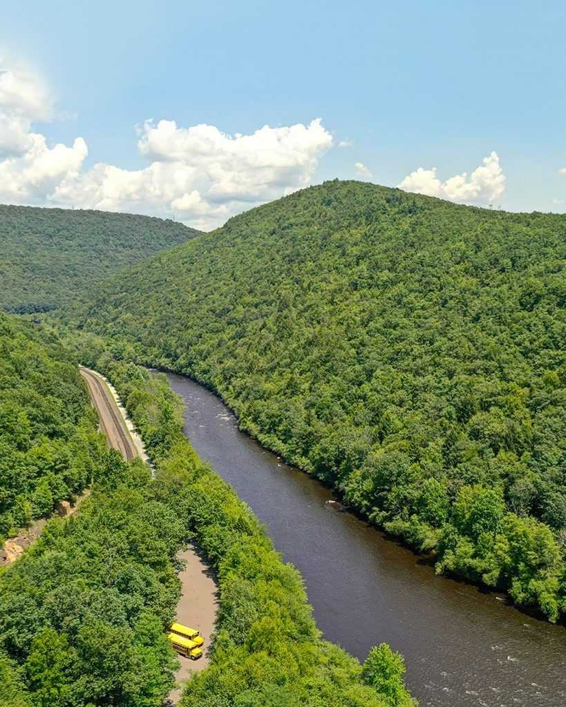
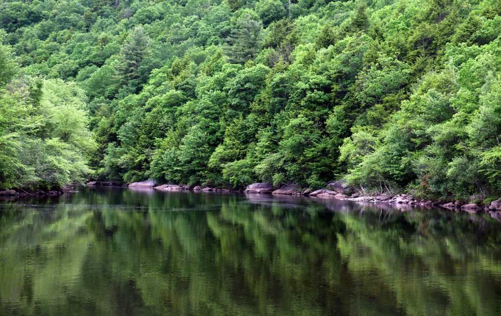
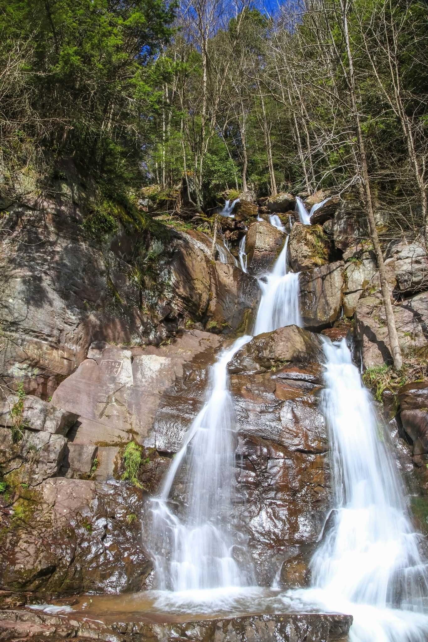
Lehigh Gorge State Park is known for its deep, steep-walled gorge, waterfalls, and a lot of greenery. It also has a lot of rock outcroppings.
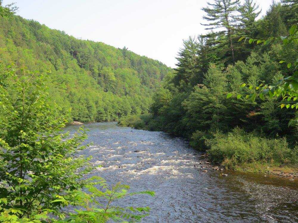
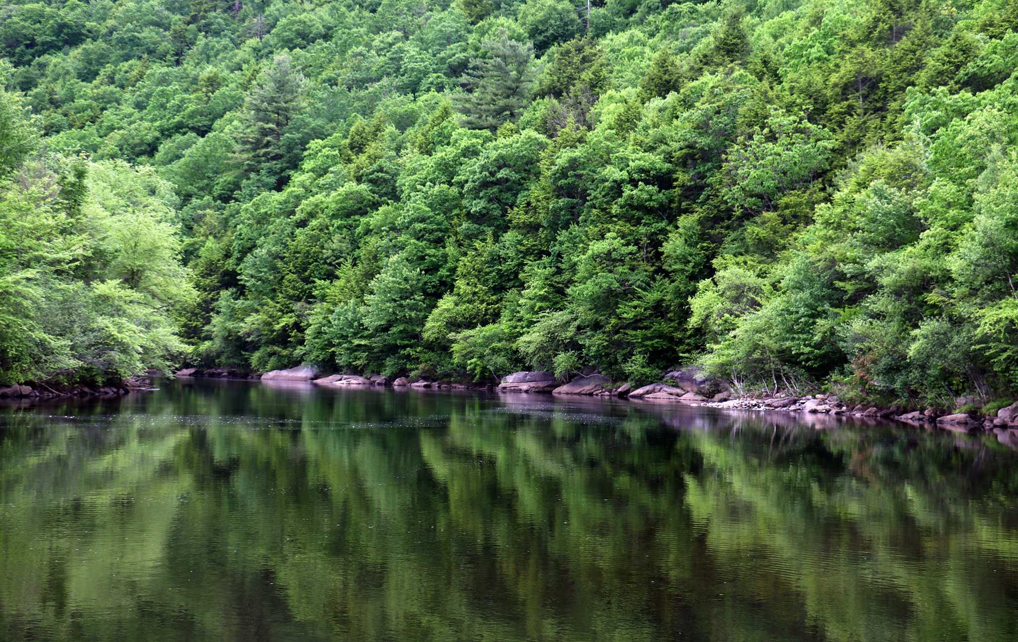
The park runs along the Lehigh River in Luzerne and Carbon counties in eastern Pennsylvania, from the Francis E. Walter Dam’s outflow at the park’s northern end to Jim Thorpe at its southern end.
The two most popular sports are biking and whitewater rafting.
From Francis E. Walter Dam in the north to Jim Thorpe in the south, the Lehigh River is followed by 6,107 acres of parkland.
The Delaware and Lehigh National Heritage CorridorOpens In A New Window, a 165-mile route, is built on the D&L Trail, which is followed by the Lehigh Gorge Trail for more than 20 miles.
Opportunities for hiking, biking, sightseeing, and photography are present along the river’s abandoned railroad grade. Vehicles cannot travel on the path.
In White Haven, Rockport, and Glen Onoko, parking spaces are available. Lehigh Tannery has very little parking but doesn’t allow boat launching.
Lehigh Gorge State Park Activities
Hiking
The Gorge is a natural location with risks including steep and perilous terrain and swift-moving water, so hikers need to be careful of this.
Boating
Whitewater boating is one of the park’s main draws. Rafting, kayaking, and canoeing are popular on this Class III whitewater part of the Lehigh River. The Lehigh River must only be entered and exited at the specified locations. The U.S. Army Corps of Engineers at the Francis E. Walter Dam and the streams that enter the river throughout the park regulate river flow. On the website of the U.S. Army Corps of Engineers, you may find information on the dam’s flow rates and scheduled water release dates:
Bicycling
Bike riding is permitted on the Lehigh Gorge Trail. It’s advised to use wide tyres.
Auto/Motorcycle
For details about auto/motorcycle trips, kindly contact the park.
Camping
To learn about the availability of nearby campgrounds, please contact the park.
Fishing
Fishing is allowed during the seasons set by the Pennsylvania Fish and Boat Commission in the river and streams. Anglers prefer to fish in the northern part, which runs from the Francis E. Walter Dam to Sandy Run, since it has been stocked with trout. To encourage fishing in this area, whitewater boating is prohibited between the Francis E. Walter Dam and White Haven.
Historic Sites
For information about historical and cultural tours, please contact the park.
Hunting
The majority of the park is accessible for hunting, trapping, and dog training during certain seasons. Deer, turkey, bear, and small game are common game animals. State game lands 40, 141, and 149 that border the park are also accessible from the park.
Winter Sports
Cross-country skiing is permitted on the Lehigh Gorge Trail, which runs from White Haven to Glen Onoko along the western bank of the river. Snowmobiles are permitted on the 15-mile stretch from White Haven to Penn Haven Junction.
Lehigh Gorge State Park History
The rise of anthracite coal mining, which was once the hub of northeastern Pennsylvania’s high-tech industry, is connected to the history of Lehigh Gorge State Park. It is also connected to the early to middle Canal Era in the United States, the quick advancement of railroading technology, and the ensuing acceleration of the building and usage of railways, all of which contributed to the Pennsylvanian and North American Industrial Revolution. The need for alternative fuels became urgent in the 1790s as a result of deforestation in the American East, just as it had in Britain a century earlier. Because of England’s experience with coal, many people were willing to invest in projects to mine and ship anthracite east to the Delaware River, where it could be barged to the cities along the east coast of the United States. The success of Britain’s industries and its emergence as the single global power at the end of the Seven Years’ War were largely attributed to England’s evident technological advantage and its enormous canal system.
While four to five mules each required a person to guide them and their cargo to be painstakingly loaded and unloaded at the start and conclusion of each day’s march, eight mules could carry a tonne of weight. It was the end of an era that had persisted for millennia when transporting large quantities of goods over long distances was only feasible by water. As a result, roads were little more than unimproved tracks that were frequently encumbered with muddy ruts or rocky obstacles as they wound around trees and along ridgelines while attempting to avoid streams. Wagons were only functional on locally developed roads, and as there were few methods to form a big enough work party to build roads even within a township due to a historic labour scarcity and the absence of distinguishing feudal systems, most of them remained crude. Traditional Amerindian pathways or game routes did not easily coexist with carts or waggons, and bridges were few in Pennsylvania’s rain-bless valleys where streams swarmed around the bottom of every valley.
1790s–1820
A hunter found high-quality coal on Sharp Mountain in 1791, above the steep-sided valleys surrounding Tamaqua. However, the news soon sparked the discovery of other coal deposits, including one at Summit Hill, a minor peak on Pisgah Mountain six miles due east of Tamaqua and much closer to the ship-navigable Delaware watershed. From Summit Hill, the Lehigh River’s rapids were only a few days’ worth of mules’ travel away, and larger boats could Both mineral discoveries paved the way for the area’s quick growth as a coal mining region. The Lehigh Coal Mining Business (LCMC), a joint stock company, started mining coal for profit at Summit Hill in 1792. Soon after, more coal mining operations started up the Susquehanna in a third watershed, the Wyoming Valley to the west of the Poconos, the Schuylkill Valley to the west of Tamaqua, Pennsylvania, and farther south along the Ridge-and-Valley Appalachians. It should come as no surprise that the bankers of the day were eager investors prepared to support projects that promised to transport supply to new markets, given the underlying demand for fuels. When these investors banded together to maintain the English model of building canals connecting major towns of source and supply, carried across viaducts above streams to facilitate affordable bulk material transfers, the gorge became historic and not simply beautiful. By the early 1820s, the Lehigh Coal Mining Company’s new management would pave the way, the LCMC would cease to exist as a subsidiary business, and it would play a significant role in one of the country’s first vertical mergers.
The transitional 1820s
A group of Philadelphia foundry owners, led by two well-known for their innovative thinking, leased the mining rights and took over the operation of the Lehigh Coal Mining Company in 1818 because they had become weary of the company’s intermittent and inconsistent supplies. Within a few months, they had also established the “Lehigh Navigation Company” (LCN) to construct navigations up the Lehigh to a point where barges, rather than just cargo boats, could be loaded with more coal, and more importantly, to tame the numerous rapids that had swept away numerous coal boats in the previous ten years. The Lehigh Navigation Company (LCN) had little problem finding employees or gathering the necessary funds to build the lower Lehigh Canal, which extends to the southern outlet of the Lehigh Gorge, since this early 1818 proposal would place coal within 12 miles of a dependable water transport route to Philadelphia. Other canal projects, including the Erie and Morris, Pennsylvania, and Delaware & Hudson canals, would be inspired by the project as well. Up to the junction of the river and Nesquehoning Creek near the mouth of the Gorge at the flats below Mount Pisgah between Mauch Chunk and Nesquehoning—a huge curving flat bottomed former lake bed between sheer sided valley walls—all downstream navigations had dams and locks in place by 1820. Therefore, the lower river had been controlled by LC&N, and a mule road was running consistently enough to bring coal from Summit Hill and the newly-opened mines at what are today Lansford and Coaldale in a timely way.
The two corporations combined to become the Lehigh Coal & Navigation Company, the organisation that would tame the canyon, by 1822 when the navigations had reached the wide lowlands of Mauch Chunk. The Upper Grand Section of the Lehigh Canal was founded in 1824 after ambitious improvements through the Gorge between White Haven and Jim Thorpe and a rail link from the Susquehanna at Pittston that would allow goods from Pittsburgh and the Ohio river valley as well as coal from the Wilkes-Barre area. By 1824, the Lehigh Canal was shipping record amounts of coal and adding further navigations creating a two-way barge highway.
1830s canal days
By the middle of the 1820s, spurred on by the success of the LC&N and the Erie Canal, the state legislature had established the Canal Commission and had started funding the survey work and construction of the future Pennsylvania Canal—which was still in the planning stages, railroads being a new, unproven technology in its infancy—as well as to build an actual long canal channel between the Schuylkill basin (Delaware Valley) and the Susquehanna (connecting the Potomac By the early 1830s, other groups had made the case that the long channel through Pennsylvania’s large valley would be costly and that, given the knowledge gained during the construction of the Allegheny Portage Railroad, a similar project could be built alongside navigations through the Lehigh River Gorge. By then, despite the early lack of power and speed in the untried railroad technologies, the city fathers of Baltimore were actively competing for the trans-Allegheny trade by incorporating the ambitious goals of the Baltimore and Ohio Railroad to surmount to the Monongahela and Ohio valleys via the Cumberland Narrows mountain pass. In addition, LC&N built the 18-mile loop of the Mauch Chunk & Summit Hill Railway (1827), the country’s second railway and one of its first tourist attractions, which is thought to have served as inspiration for the roller coaster. It continued to serve this purpose in the tourist industry until the 1930s, when it was sold to Japan for scrap. The Lehigh and Susquehanna shortline railroad was built from wharves across Wilkes-Barre between its suburbs Pittston and Ashley, climbing Mount Penobscot on the Ashley Planes Inclined Plane Railroad. By 1837, a proposal to extend the Pennsylvania Canal had been passed, enabling the LC&N to lead the construction of a similar gravity railroad from Penobscot to White Haven.
Lehigh Gorge and its swift streams, on the other hand, stood in the way since barges could not navigate them. Due to the eighth tonne practical limit per mule, this forced the use of a sluggish mule train, which is labor- and money-intensive. The Lehigh Coal Mining Company’s delivery of partially barged and partially mule-trained coal became erratic and infrequent after 1818, as fuel shortages became more severe. This issue was resolved by Josiah White, who leased the operating rights, established the Lehigh Navigation Company, and started to meticulously put in place the initial series of dams, locks, and channel improvements of the navigation from Easton on the Delaware the 40 miles up to the Mauch Chunk Creek, outletting in area of today’s Lehighton, where the streamside trail was the mule trains’ quickest descent to reach the river about twelve miles from the Summit H. By 1820, the navigations had resolved the majority of the barging problems, a road from the mines had been steadily improved, alleviating teamster concerns, and the ventures had started to generate a sizable profit. By 1822, the two companies had been combined to form the Lehigh Coal & Navigation Company, and the navigational works and the mule road had been rerouted so that they reached Mauch Chunk, with the mule road being high enough to dump coal by chute By 1824, the company had plenty of cash, had been constructing two-way locks on the lower river and looking for other sources. It started purchasing more coal-producing land, and eventually acquired land near Hazleton and Ashley as well as the saddle-shaped mountain pass at Penobscot, Pennsylvania (now Mountain Top), which is located above both south Wilkes-Barre on the Susquehanna and White Haven on the Lehigh at the head of the gorge.
By altering the river, LC&N constructed Navigations down the canyon, originally reaching the foot of Mount Pisgah in Carbon County, Pennsylvania, near the intersection of the Pisgah and Nesquehoning ridges. Between what was then called as Mauch Chunk (now Jim Thorpe) and White Haven, 29 locks and 20 dams were constructed. In the middle of the 19th century, significant flooding wrecked the Upper Grand Section of the Lehigh Canal, which was subsequently rebuilt by railways.
From Mauch Chunk to Easton, a railroad line for the Lehigh Valley Railroad Company was constructed between November 1852 and September 1855, primarily to Asa Packer’s own credit.
Lumber
John James Audubon, a naturalist and painter, spent more than a month capturing the birds of the Lehigh Gorge in his paintings. The gorge was entirely uninhabited at the time, but Audubon could see that this situation would soon change. In the middle to end of the 19th century, there was a high demand for timber, and a large portion of Pennsylvania’s forests were cleared of all vegetation. The Lehigh River was used to harvest the old-growth white pine and hemlock trees in Lehigh Gorge and send them downstream. The bark was used in tanneries to manufacture leather, while the timber was used to make lumber. Lehigh Tannery, a tiny village along the Lehigh River, was home to the second-largest tannery in the United States. By 1875, the majority of the timber that could be sold had been clear-cut, leaving a large amount of dried treetops and other woody waste on the ground. The large forest fire that year was started by a spark from a passing coal-fired steam engine and destroyed the debris, the remaining standing trees, the sawmills, and their lumber stocks. The Lehigh Gorge’s lumbering age came to an end as a result of this forest fire.
From resort to state park
At the start of the 20th century, Lehigh Gorge briefly served as a vacation destination. In order to get to Glen Onoko, a vacation region, railroads ran tourist routes. In addition to tennis courts, a dance pavilion, and trails leading to the picturesque Glen Onoko Falls, the resort hotel there featured 47 rooms. People looking to escape the Northeastern United States’ dirty cities were extremely drawn to this region. The Lehigh Gorge region was mostly forgotten until the 1970s when a fire in the 1910s decimated the hotel and its surrounding woodlands. The Central Railroad of New Jersey’s main line through the Gorge was abandoned in 1972, giving the route the required space. This right-of-way was acquired by the Commonwealth of Pennsylvania from the Reading Company, and as a result, Lehigh Gorge State Park was created in 1980.
Transportation
Driving
The northern entry point is White Haven, which is accessible via I-80 Exit 273. To reach the White Haven Shopping Center, follow PA 940 east. The state park entry location is on the right after turning right onto Main Street. Following US 209 south from Jim Thorpe to PA 93 north will take you to Rockport, which is the main entry point. Turn right onto Brenckman Drive to reach Weatherly after six kilometres. After Weatherly, continue on and take a right left onto Lehigh Gorge Drive. Take Rockport Road to the right. From Exit 273 on Interstate 80, you may reach Rockport from the north. After travelling one mile on PA 940 west, turn left onto Lehigh Gorge Drive. Turn left onto Rockport Road when you reach the quaint community of Rockport.
Parking
Parking is available.
Public Transport
Public Transport is available.
